We've Upgraded Our Maps
When you use our site you may have noticed that we use Ordnance Survey mapping for some of our maps (in the maps introducing each walk for example) but for licensing reasons we use an alternative set of tiles we were given, which we called OpenMaps, for most mapping e.g. the location of hills, the subjects of photos in our gallery, or the little maps shown for each step of our walks.
The OpenMaps tiles were a mash up of Ordnance Survey Open Data mapping and contours and paths and tracks from OpenStreetMap and were first created in 2011 and they were getting a bit long in the tooth.
So a little while ago we started looking at whether we could replace them and we've now come up with WayMaps, which is built from open data from a number of sources put together with our own styling. After a lot of work preparing these map tiles we have now rolled them out across the site to replace the old mapping.
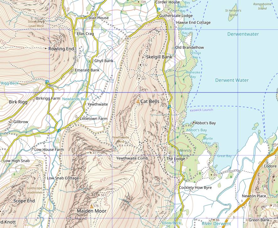
Here's an example of how it looks:

Things to note:
- As with OpenMaps paths and tracks are derived from OpenStreetMap data but of course this is the very latest, not the 2011 data, and we've rendered it to look more like Ordnance Survey in style.
 In England and Wales we've marked all the access land in the same background colour used by Ordnance Survey so it should be easy to work out whether you have the right to roam.
- Contours are now labelled with their height.
- We've including all the Ordnance Survey trig points plus something which isn't even on their own maps: OS survey blocks as some remain on places like Blencathra (as shown in our photo). Note that there is often no trace of these on the ground any more - there's apparently one on Latrigg for example but it's long since disappeared.
- In the Lake District we've marked every Wainwright summit location with a coloured triangle with a dot in the middle, the colour being the colour of the related Wainwright book e.g. orange for North Western Fells as shown on Cat Bells and Maiden Moor above.
- Similarly in Scotland we've marked every Munro and Corbett with red and blue triangles respectively.
As well as being more up to date we think the mapping is easier to read, especially when zoomed out. We've also got 1:25,000 scale tiles now which in turn improves the readability of the maps for our steps in our walks where the route is complicated over a short distance.
We welcome your feedback on what you think of WayMaps, either publicly in the appropriate forum or via email.
By the way this isn't the end of the story of WayMaps, far from it. Now that we've mastered generating our own tiles we intend to take regular updates from the open data sources we're using, especially OpenStreetMap, and so our mapping will always be up to date.
You can comment on this post in our forum.
Participants in these activities should be aware of and accept these risks and be responsible for their own actions.